Everything Everywhere All the Time: Achieving Persistence with Space-Based ISR
As someone who has worked at a high level in large-scale federal agencies and in space operations for over 25 years, I’ve always been interested in persistent intelligence, surveillance, and reconnaissance (ISR) because it unlocks new mission utility. While leading Activity-Based Intelligence (ABI) programs at the National Geospatial-Intelligence Agency (NGA), I endeavored to combine multi-domain and multi-INT data in different ways to achieve necessary levels of persistence to achieve information advantage. Information advantage is the goal of ISR. From a dominant space technology infrastructure built during the Cold War, to total air superiority enabling airborne ISR overwatch during the counterterrorism era, the U.S. and its Allies have enjoyed that ISR advantage for more than 40 years. However, over the past decade the geopolitical landscape shifted as western defense strategies recognized with rising and resurgent threats to global stability. Thus began an era known as ‘strategic competition’. Any military conflict with strategic powers will now suffer from a lack of air superiority coupled with the expectation of a debilitating cyber campaign, thus requiring space-based ISR for consistent information advantage. Learning from counterterrorism outcomes, the military intelligence apparatus today understands the value of persistence—a concept loosely defined as monitoring any information signal at the rate of relevant information change. Persistent ISR has been used to successfully monitor known threats (e.g., weapons production facilities) and to conduct real-time forensic analysis to rapidly discover emerging threats. This tradecraft has been referred to as geospatial multi-INT fusion and Activity-Based Intelligence (ABI). It has never been achievable from space alone.
What is Persistence?
In 2018, the Dr. Joseph Koller at the Aerospace Corporation published a paper called “The GEOINT Singularity” which postulated that someday there would be enough GEOINT collection capability in space to monitor and track all human-sized objects and activities on Earth all the time. This became a believable idea due to the miniaturization of space hardware and the proliferation of launch capacity to support small satellite mega constellations such as StarLink, OneWeb, and Kuiper. By replacing communications payloads with ISR payloads, persistent space-based multi-INT ISR becomes possible. Speaking solely for Geospatial-Intelligence, or GEOINT, when there are enough electro-optical (visible), synthetic aperture radar (SAR), infrared (IR), and hyperspectral imaging (HSI) systems operating in orbit; coupled with robust computer vision (CV) enabled by artificial intelligence (AI) running at scale; it may become possible to continuously observe and track every building, road, rail line, surface ship, aircraft, train, and ground vehicle on the planet all the time (or at least once every few seconds). This is persistence. This is the GEOINT Singularity. But we are getting ahead of ourselves…
The Challenge.
Several key technologies still need to mature before this ideal notion of geospatial persistence can be achieved. Additionally, the investment in space-based collection capacity will be staggering and to date no government and no private investment group has been willing to take that much risk. Mass production of low-cost EO, SAR, and IR sensors is needed to proliferate thousands of ISR satellites. It is necessary for either a) on-board processing or orbital compute to reduce the ISR data stream at the source; or b) more communications bandwidth to become available for moving ISR data from space-to-ground. Finally, both the accuracy and precision of CV models must improve for autonomous tipping/cueing and object identification/tracking to be effective and trustworthy. While there have been individual successes that continue to move the private space economy closer to the goal, we are far from being there.
Modeling Outcomes.
To appropriately understand what achieving persistence means, it is necessary to model outcomes using realistic mission scenarios. Persistence is best defined as sufficient ISR collection to capture the rate of information change needed for a mission use case. In the case of maritime domain awareness, observing all ships at least once every 15 minutes has been deemed sufficient for tracking ships and observing patterns of activity. Ships don’t move all that fast and because of physics they tend to have predictable trajectories. In a separate mission use case, monitoring a specific ground vehicle as it navigates an urban landscape may require observations every few seconds from vantage points not obscured by the terrain (i.e. tall buildings). This is a far more stressful scenario for achieving persistence.
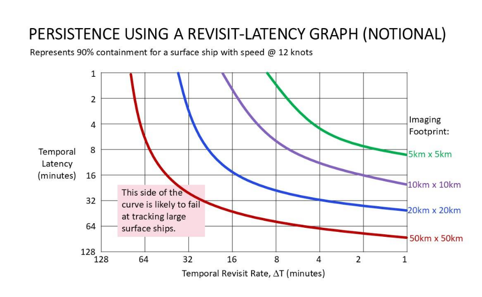
Every mission use case therefore has unique spatial, spectral, and temporal components that comprise its requirement for persistent surveillance and ABI. A simple method for modeling these success criteria is to use a revisit-latency graph showing a minimum requirement for each mission use case and sensor type. In the case of the graph shown below, the notional boundary is for a persistent imaging strategy to track a surface vessel moving at a speed of 12 knots. Collecting high-revisit imagery is relatively straightforward given the types and numbers of commercial remote sensing instruments available on the market today. However, a successful ship tracking strategy also requires ISR data to be delivered with low enough latency to adjust to changes in the ship’s direction; a capability that is not readily available today. There are ongoing efforts to better characterize this trade space using actual commercial remote sensing constellations, advanced collection planning tools, and low-latency data delivery for a variety of mission use cases. It is also an active area of research to model these scenarios and employ AI tools that can generate successful collection tasking plans across sensor types and constellations.
A Near-term Solution: Virtual Constellations with Direct Downlinks.
The immediate goal is to simultaneously increase ISR revisit rates while decreasing information latency. Increased revisit rates can be achieved by aggregating the individual collection capacities of multiple companies into “virtual constellations” that can act effectively as one. Similarly, decreased latencies can be achieved by the immediate downlink of ISR data across multiple terminal providers instead of waiting for one ground station network provider to capture all their ISR data from space. There are market opportunities for intermediary companies to fill these gaps by providing enhanced services through aggregation, integration, and optimization. Custody of certain vessels of interest (not all of them) will be possible in the near-term with these enhancements.
A Long-term Solution: Proliferated Constellations with Meshed Optical Networks.
Individual companies are already on track to proliferate constellations in LEO towards persistence or to move ISR sensors to higher orbits such as GEO which naturally offers long-dwell ISR capabilities. Perhaps the greatest step-function in capability, however, will be the moment in-space meshed optical communication networks begin to offer seamless and light-speed ISR data relays to the global Internet. When both improvements occur, there will likely be a sensor monitoring every inch of the Earth with data instantly provided to massive AI models to determine relevance. This unlocking technology will finally enable the ABI tradecraft to discover new threats as they emerge (e.g., wildfires) while also warning us of known threats (e.g., enemy movements) in almost real time.
My personal view on the future of persistent ISR is that it will continue to elude us for several years even as fundamental technologies such as those mentioned above soon begin to emerge. This is because higher fidelity data is often prioritized over persistent sources. Additionally, the resources for large scale data reduction and fusion analytics continue to be a barrier to global collection. Until then, we must solve what issues we can with the nearly-persistent data and tools that are available.
About the Author:
David Gauthier brings nearly three decades of experience in U.S. national security as a military intelligence officer, technology innovator, and IC senior leader. As Chief Strategy Officer for GXO, Inc., he helps private space industry innovators improve security-related services. Mr. Gauthier is also a Senior Associate with the Center for Strategic Intelligence Studies (CSIS) and a Fellow with the National Security Institute at George Mason University.
What do you think? Share your thoughts and join in the discussion around data centricity and literacy in GEOINT at the 22nd annual DGI conference in London from Feb 23-25, 2026.